A Russian Communications Map, ca. 1685.
LEO BAGROW
A number of Russian historians have of late devoted their work to the study of communications in ancient Russia. The works of S.V.Bernstein-Kogan on the Route of the Varangians to Constantinople (1) and of J.A.Golubtsev on the 17th-century roads in the Province of Novgorod (2) have been published. V.A.Petrov published "The Book of 17th-century Russian Communications", appending to it a commentary (3) and a road-map of his own compilation made in conformity with the ancient Russian text, as no original old Russian road-map— except the map of the Province of Novgorod recently found by Golubtsev and an Ukrainian map also made in the 17th century simultaneously with the compilation of a new copy of the Great Map (General Map of Russia) in 1627—have been preserved to our day. Another researcher in this domain, K.N.Serbina, has already introduced readers to the series of her works devoted to the study of the various surviving texts, comprised in The Book of the Great Map, describing the routes all over Russia with indication of the roads and distances between different places (4). K.N.Serbina does however not agree with my own point of view and that of other Russian historians that the "Map of Ukrainian and Cherkassian Towns" (further referred to as "The Ukrainian Map"), which I found in Stockholm, is the very map—or a later copy of it—made simultaneously with the Great Map of 1627. According to Serbina, the data given on this map do not agree with the text of the "Book of the Great Map".
In any case, as mentioned above, only two maps have hitherto been known to us: The Ukrainian Map and the Map of the Provinces of Novgorod and Sweden. The last-mentioned presents data only on the main routes and the respective distances between towns, while on the first-mentioned the routes proper are traced out. A distinction of the routes is made: the more important "shlyakhi" are the courriers' routes and the less important are those connecting provincial towns. In representing the last-mentioned roads the distances between the towns are, for the most part, indicated, while the distances on the more important roads are in but few cases presented (5).
During my researches in the Bibliotheque du Service Hydrographique de la Marine in Paris, I found a large manuscript map on paper measuring 117 X 104 cm and representing the southern half of European Russia. It is in the Atlas (No. 4026 B) containing various maps formerly owned by G.Delisle. This map, from its appearance, can be ascribed to the late 17th century. According to data found in literature, Nakoval'nik and Solomein were, in 1685, entrusted with compiling a map of South Russia. As no other references exist to any other map made in South Russia, I was led to believe that the map I found was precisely this one (6). However, when I now examine it more closely, I see that I had been too hasty in making this conclusion: the area comprised in the map is much larger than that which Nakoval'nik and Solomein were charged with recording and, besides, the material it contains is much more ample and of a different character than might be expected in their map.
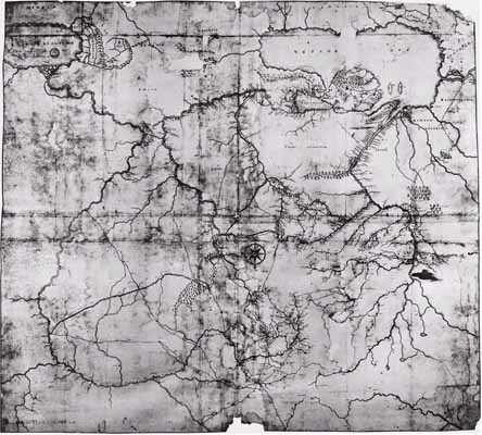
The map represents the area comprised between the river Don with the lower course of the river Pripyat' and the whole of the Volga, with the exception of a small part, for which there was no room on the map; the lower part of the Kama, up to Vyatka, and part of the river Vyatka; in the north—the W. Dvina, from its sources to its estuary in the Gulf of Riga (More Varyazhskoye = the Varangians Sea); in the south—almost the whole of the Khvalynskoye Sea (the Caspian Sea) is also present, i.e. its south coast—the coast of Persia — Caucasia, Anatolia, the Sea of Marmara with Tsargrad (Constantinople); in the south-west — Adrianople'; the estuary of the Danube, the lower course of the Dnester and the rivers Bug, Ingul and Ingulets. Naturally, the Black Sea and the Sea of Asov and Crimea. The (so-to-say) border-regions and waters, as well as the adjacent land included in the map, are very poor in details: only a few towns and their respective names and a few names of countries are indicated, this being evidently not included in the compiler's task.
The mountains and mountainous region in the central part are not indicated. Only in the south the relief is in a few places represented.
Before making any speculations as to the chronological date of the map, we ought to establish for what purpose this map had been made.
The ramparts or abattis (7), which were built with the purpose of protecting Moscow State against the invasion of the Nagaian and Crimean Tartars, are indicated in the map. This line of defence begins east of the Volga, at Simbirsk (1648), and, with interruptions and branches goes on to the Donets, crosses it, and reaches the river Vorskla at Khar'kov. Here finish all the lines of defence, which take their start on the Volga at Simbirsk and finish at two terminal points—the one at Khar'kov in the north, and the other—more south, at the sources of the river Kolomok.
Passing on to a survey of the roads, it is necessary to remark that the map is in the main a map of communications — by land and water — and that all the roads are directed from Moscow to the periphery, but do not connect separate places so-to-say in parallel. The most important of the rivers also present, however, such possibilities of communication too.
The roads from Moscow run out from it in rays. There are only two roads leading to the Volga, in a northerly direction: to Tver' and to Yaroslavl'. The rays, read clockwise, are directed as follows: Moscow-Vladimir-Simbirsk with a branch from Vladimir to Saratov. At Simbirsk the road is cut off by the beginning of the abattis stretching from the Volga; the road to Saratov crosses the same abattis at Insar.
The second ray runs from Moscow to the river Khoper. The fortified point, or town, on the river Khoper is not indicated. Later it is the Khoper-fort. The road twice crosses the abattis, at Kozlov and at Tambov.
The third ray, like all the rest, takes its start from Moscow, and at Toula branches in three directions; two of these branches meet again further on, at the Gundor river-crossing and end at Cherkassk, while the third later on joins the fourth ray from Moscow directed to Kiev.
The abovementioned third branch, running from Toula, joins, at Sevsk, the next ray from Moscow directed to the Danube and running via Kiev-Tripol'e-Kanev-Cherkasy-Chigirin-via Cherny Less, crossing the rivers Ingulets, Ingul, Sinyukha, Bug, Sevran', through the forest Kuzman' (in Beauplan the Kusimani Szlak runs here) to Taguin, or Bender, across the Dnester to Izmail on the Danube.
In characterising these land communications it is necessary to notice that the distances between all the abovementioned places are given in versts and are written in Slavonic figures, with their translation into Arab figures added later.
The rivers, completing the communication scheme of the map, serve as an extra means of communication, i.e. they either connect the same terminal points as the roads, or provide means of communication in places where the roads are cut off. Although there are many populated places situated on rivers, traffic was evidently not encouraged on all these rivers or parts of them, for there is no indication of the distances which would have served for fixing the fare between these places, if this map was meant to be a supplement to the "Record of distances" (8). There is no doubt, however, that e.g. the W. Dvina, which is drawn at full length on the map and on which a few important towns are indicated, or the whole of the upper course of the Dnieper with its affluents up to Kiev, might have been used as river-communications and were most probably used for this purpose. But why were the distances not indicated? Let us examine in detail these river communications.
The Volga is represented with an interruption in the north, i.e. the upper course of the Volga, from Tver' upwards, is recorded on the map; then, after an interruption, it continues from Yaroslavl' down to the Caspian Sea. The road from Moscow to Tver' seems to complete the route from Moscow to Rzhev Volodimirovsky. There is no direct land communication between Moscow and the upper course of the Volga. The road from Moscow to Yaroslavl' is cut off at this point, and on this part of the Volga, down to Balakhna, the distances are not indicated. Further on, however, from Balakhna to Astrakhan and even down to the sea, they are indicated. All the left-hand affluents have no indications of distances, which are given only between Kazan', Malmyzh and Urzhum.
Of the first affluents of the Volga, distances are given only for the Oka, from Nizhny Novgorod to Kromy. For some reason the "river-way" between Kassimov and Pereslavl' Ryazansky is particularly stressed. The distances are also given for some of the affluents of the Oka, which completes the network of communications, and for the upper course of the Don, up to the river Sosna, approaching this region. Lower, the Don is again included in the system of communications, i.e. with an indication of the distances between the points: from Kozlov to the river Voronezh, opposite the inflow of the Vedoga from the right and down to Korotoyak, and then, below the Donets, all the rest of the Don down to Cherkassk. Further on, the delta of the Don and the coast of the Azov Sea are not included in the network of communications; having said the same of the river Kuban', we need not return to this region.
As for the Donets, the distances are given only between Izyum and Bolkhov and for the affluents in its upper course — the Ud' and the Mozha, i.e. the regions comprised in the system of defence.
There remains the Dnieper. It has already been mentioned above that the Dnieper is included in this communication system only from the inflow of the river Desna downwards. Distances are not indicated for all its affluents, but only for the Desna, Sula, Psel, Vorskla and the lower course of the Orel. Only some of the first affluents, as the Irpen' and a few others, bear any indications of distance. On the Dnieper proper there are such indications only in two places — apparently, from Krylov to the Cataracts, and from the Cataracts to the fort Kis-Kermen (today Berislav). From Kis-Kermen a road runs to the sea up to Ochakov, whence the Chumatsk road leads to Perekop, crossing the Dnieper at fort Tugan and Khon Burum (on the map Mustrit Kermen) and continuing between Chernaya and Zelenaya Dolina, over Kalanchak and Belye Vody.
The abattis had in many parts lost their primary significance about the time when the map was made. Colonization had already extended beyond the limits drawn by them; they were no longer of importance because the colonists seem not to have minded so much the still continuing invasions of the Tartars, especially from the Crimea. During the period 1651-1581 new colonization overran the recently completed line of defence running along the North Donets and the Kolomak, comprising the towns Tsarevoborisov, Soleny (Slavyansk), Balaklea, Bishkan, Zmiev and Valki. No new lines of defence were erected in these parts. In the eastern Volga-district, on the contrary, though the native peoples had been subdued towards the beginning of the 17th century, revolts began to blow up in the middle of the century and it became necessary to build a new rampart against their attacks. The old abattis, broken off at Simbirsk on the Volga in 1648, was now completed on the other side of the Volga—via Belyi Yar - Bilyarsk to Menzelinsk on the Kama. This, so-called, Zakamsky line of defence (1652-57) is not recorded on our map. If the absence of this line can be explained by the fact that the area situated to the left of the Volga is left unnoticed, the absence of the more southern — Syzransk — defence line, built from Syzran' to Penza and stretching in the north to Nadeino Ussol'e (the latter separates the whole of Samarskaya Luka with the Zhiguli), must have some other explanation. Syzran', the starting point of this line of defence, was founded in 1683. The invasions of the Bashkirs and of various other restless peoples troubled the local population. This led to the construction of a new line of defence south of Samara, beyond which colonization had already extended. The construction of this line was led from Syzran' in two directions—to Ussa, and from there on to Ussol'e. Syzran' is indicated on the map, but the line is not represented. The conclusion can be drawn that the year 1683 was the last recorded by the cartographer, whereas the work carried on during the two succeeding years was unknown to him.
The technical execution of the map, regarded from the viewpoint of Russian cartography of those days, could not have been any better. Compared to the Ukrainian map, it is a big step forward. Unfortunately so few original manuscript maps of that time have survived to our day, that it is impossible to range them in types. The Siberian maps made in Tobolsk belong, for the most part, to Remezov's school (1667-1710) — of all three generations. But the map of Siberia of 1672 made in Moscow bears much resemblance to the Ukrainian map in the manner of its execution. This is another type — the Moscow school. Finally, the present map, having in general preserved the character of Russian maps of those days oriented with the North at the bottom, presents some signs of evolution: the lines representing rivers are more rounded, in some places the relief of mountains is given, and it has a compass-rose of quite European type. In those days, experienced designers used to work in the Oruzheinaya Palata (Armoury). They executed all sorts of drawings, including maps. One of these artists, Stanislav Loputsky, a nobleman from Smolensk, was engaged at the Armoury; he was considered to be a great master of his art; pupils were sent to him (9). This was in the reign of Tsar Alexei Mikhailovich. The assumption can be made that our map was made, if not by Loputsky himself, by one of his disciples from the Armoury.
In conclusion I want to indicate a few separate regions on the map which attract one's attention and deserve to be studied in closer detail. In the first place stands the lower course of the Don and the Azov Sea. The town Azov still belongs to the Turks and the entrance to it on the Don is protected from the north by two towers. Besides the northern coast of the Azov Sea, the eastern coast with the Taman' Peninsula and the river Kuban' must also be included in this section of the map.
Exactly the same outline of the Crimean Peninsula was preserved in Russian maps of a later age. Captain Frauendorf had apparently based on it his map of the Azov Sea and the coasts of Crimea (1735) which J.Delisle printed in the Academy, thereby arousing great displeasure in the Commanding Corps of the Russian Army during the war in the Crimea against the Turks in 1736-37, for the information presented on this map was far from correct.
The representation of the lower course of the Dnieper up to the Cataracts is very original — the main cataracts are drawn and named, but their order is confused. In the enumeration of the cataracts included in "The Book of the Great Map" the indication can be found that "the Cataracts are drawn according to a description given by the Zaporozhie men". Here they are for the first time represented on a Russian map on which the map of Beauplan had no influence.
The part of Ukraine situated to the right of the Dnieper and comprising the town Kiev, which had passed over to Moscow according to the peace treaty with Poland at Andrussovo, 1667, and later also according to the peace treaty with the Turks and the Crimea at Bakhchisaray, 1681, presents considerable interest.
The Caspian Sea had preserved an almost Ptolemaic shape. The map of the sea, made in 1640 by the Dutchman Clausen to orders issued from Moscow during the construction of the fort in Tarki, was evidently unknown to our cartographer. On the west coast of the sea everything lying between the Terek and the Kura is quite mixed up; the rivers Terek and Kura are combined. However, even this region presents a certain interest.
I shall not dwell on the area of colonization in the steppe south of the abattis. Though the material in this section of the map is rather scarce (it is mostly blank spaces), if one followed up point after point according to the date of their foundation, it would perhaps be possible to establish the date of the production of our map. At present I establish it to be, according to the date of Syzran' and the defence line of Syzran', 1683-85.
Comments:
(1) Put' iz varyag v greki. Voprosy geografii, 29, 1950, 239-270.
(2) Puti soobshcheniya v byvshikh zemlyakh Novgoroda Velikogo v XVI-XVII vekakh i otrazhenie ikh na russkoy karte serediny XVII veka, Voprosy geografii, 29, 1950, 271-301. With maps. The reproduction of this old map led Harald Kohlin to a comparison of the Russian map with a Swedish one of the same epoch and to write the paper published in the present volume of Imago Mundi IX, p. 94.
(3) Geograficheskie spravochniki XVII v. Istorichesky Arkhiv, 5, 1950, 74-165.
(4) See Imago Mundi V, 81-82. This text, worked out by K.N.Serbina, has recently been published: Kniga Bol'shomu Chertezhu, Moskva-Leningrad, 1950, 229 p. See p. 118 in the present volume of Imago Mundi.
(5) A reproduction in reduced size of the Ukrainian Map is appended to my notice on the work of Serbina in Imago Mundi V, 80-81. The map of Novgorod is reproduced in the present volume with the article of H.Kohlin, p. 94.
(6) I made the same statement in the text of Anecdota Cartographica I.
(7) The defence constructions are referred to in the map both as “val” = rampart and "zaseka" = abattis.
(8) See the article by V.A.PETROV referred to above.
(9) The following maps of Loputsky's workmanship are known: of 1663—a Worldmap and a map of India; of 1664—a map of Muscovy, a map of the Lithuanian Principality, a map of Ukraine; of 1668—a map of Siberia. As we see, Loputsky was even acquainted with European cartography. His Sketch of Novaya Zembla, which he sent to Witsen, was published in Philosophical Transactions 1674, No. 101, 3-4.
Source:
Imago Mundi, Vol. 9 (1952), pp. 99-101.
При использовании материалов с данного сайта ссылка на него не обязательна, но желательна : )