Some Remarks on Maps of the Crimea and the Sea of Azov.
By H. KÖHLIN, Stockholm
The Catalogue of Maps of the Black Sea preserved at the Academy of Sciences of the USSR, compiled by Alexandrov and appended to the work of Gnucheva1, can be further completed by a few works of the reigns of Peter the Great and his immediate successors.
Of these, special attention is due to two MS. maps with a peculiar round shape for the Crimean Peninsula, which, at an earlier date, had been fairly correctly rendered, with its three projecting promontories, by Mercator, Janssonius et al. This round type has left traces in many of the engraved maps up to 1769.
The present author first encountered this simplified round shape in the Russian Communications Map, ca. 1685, described by Bagrow2. A detail of this map is reproduced herewith (Fig. 1). The topographical details, the principal watercourses, the highway with its branches and the southern mountain-chains are but scantily represented. These, besides villages, towns and the renowned line of fortification at Perekop, are portrayed in perspective. The western part of the Peninsula is treated in more detail, while its eastern part is drawn in a more summary way. This is especially obvious in the area adjoining the river Salgijr. Evidently the map-maker had observed western Crimea in a journey along the highway, whereas the eastern part of it he drew from descriptions. The map is oriented with the south to the top, as viewed from Moscow.
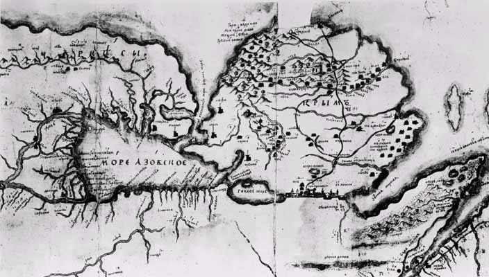
Fig.1. The Crimea, in the MS. Russian Communications Map, ca. 1685
(Bibliotheque Nationale, Paris)
An example of a similar map of this 'round' type is also extant in Sweden (Fig. 2)3 [Нумерация рисунков и ссылок на них в тексте не всегда совпадает - LV]. The Swedish map, which embraces the north coast of the Black Sea — the area extending between the Danube and the estuary of the Dnieper on a reduced scale — is likewise anonymous, undated and manuscript. The manner is thoroughly simplified — a drawing from memory — except for the Crimea, for which a prototype had obviously been used. The land surface is coloured in pale lemon-yellow and the coast is outlined in a thick, dark bluish-green line. Landscape details are drawn in perspective, e.g., trees, patches of woods, hills and villages. The title cartouche in the right-hand bottom corner is tinted in red and contains the following title: "Tabula Tartaria Perekopensis Krim dicta". The map, which lacks a scale, measures 68 x 54,5 cm. It is not rich in names, but several of the places are provided with informative inscriptions in Swedish. Thus at Perekop we read (in translation): "P. is a piece of land of 15 versts [5 верст - LV] or 1 mile." Immediately west of this: "Perekop was besieged in May A0 1689 by Generalise: Knees Wasili Wasiliwitz Galitzin, but was bribed with ducats by the Crimean Tartars." West of the Dnieper it is stated that "Last summer Kasÿkermen was conquered by Felt H:rn Boris Petrowitz Sheremetioff" [Казыкермен был взят Шереметевым 30 июля 1695 года - LV]. On the Dnieper we read: "The river Dnieper, formerly called the Boristnes." The northern route leading from Perekop to Kazikermen is described as follows: "The Zaporozhski Cozacks way to Kesyikermen 60 versts or 12 miles." The southern route to Ochakov bears the inscription: "The way to Otschakoff is two days by horse." On the west coast of the Crimea, at the town of Koilov [Козлов – Гезлеве – Евпатория - LV], we read: "Here is the best harbour for ships of the whole of Ponto." Southwest of Perekop: "Here live a few Tartar Hordes", and immediately south of this: "A big stone pier." In South Crimea, where the highway divides into two, is located the capital of that day, Bacciserai. There we read: "Baktschiharaj the capital of Crimea where the Khan himself lives", and on the river flowing immediately south of this: "Belbeck, where grapes grow." East of Bacciserai is situated the town Kale, "A town inhabited by the Jews".
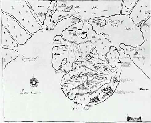
Fig.3. Anonymous MS. Swedish map of the North-Eastern part of the Black Sea
(Krigsarkivet, Stockholm)
[Данную карту в цвете и в хорошем качестве можно посмотреть здесь - LV]
On the east coast of the Crimea, beginning with the Strait of Kertch, the following five annotations are made: 1) "The crossing to Tcherkassy", 2) "Stretto di Kapha", 3) "Kapha, an extremely old town, kinsmen of the ancient Goths, as is shown by their language, also Greeks and Jews live there", 4) "Shatrovaya Gora (The Cupola Mountain), a mountain whence the whole of the Crimea can be seen", 5) "Many mountains, among which there are large villages and boroughs, the inhabitants are of the Tatschske faith and Greek laws" (see Fig. 4).
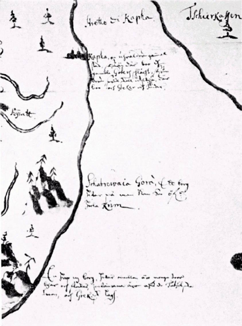
Fig.2. Detail of Fig.3.
At the top of the map, near the Don, we read: "Tscherkaskvi, the capital of the Don Kozacks, 30 versts from Azov." South of the "Don stream": "Two Towers or 'Kalanchi' conquered by his Majesty the Tsar [Каланчи Петр I взял во время первого Азовского похода - в июне 1695 г. - LV], where there is a large chain across the river, 3 versts from Azov."
These inscriptions seem to suggest that the Swede who made the map was interested in the question of the ancient Goths, whose eastern tribes had migrated from the Vistula region down to the Black Sea. About 1700 it was believed in Swedish scientific circles that these Goths were of Swedish origin. One of the Swedish scholars, who had made long journeys in quest of relics of the wanderings of the Eastern Goths, is dealt with by Bagrow in his article "Sparwenfeld's Map of Siberia"4. But Sparwenfeld, although he had lived for many years in Russia, did not have the opportunity of visiting the Crimea, as a war was then going on there, and we can see from the annotations made on the map of the Crimea that they were made from personal observations [Личное наблюдение Крыма автором карты представляется очень спорным. Более вероятно, что он воспользовался информацией из какого-то более раннего источника - LV]. However, even considerations of time do not allow us to assume that Sparwenfeld was the author of this map [Датировка карты Кёхлином, похоже, не верна. Поэтому его возражения по поводу возможности авторства Спарвенфельда представляются несколько надуманными - LV]. There were several Swedes (as we shall see from the following) who took an interest in the Goths and had visited the Crimea in this connection.
In the later phase of Charles XII's Russian operations, the King, while staying on Turkish territory, desired to establish more intimate collaboration with the Crimean Khan. With this purpose he sent from Bender in 1710 Lieutenant-Colonel S. Lagerberg as envoy to Khan Dowlet-Gheray, who was known to be favourably disposed towards Sweden5. Lagerberg departed from Bender with his commission and arrived in Bacciserai, the capital of the Crimea, on 26th December, 17106. The next winter Lagerberg accompanied the Khan in his campaign directed from Perekop to the estuary of the Dnieper and further north.
After his return to Bacciserai, Lagerberg in May 1711 received the Swedish Major General Carl Hård, whom he presented to the Khan. During a later visit, at which future operations against Azov were planned, the Major General showed a map, which he had prepared from information on the Azov region provided by Swedish prisoners7. I shall return to this map later.
In his very interesting diary, Lagerberg records that on January 21, 1711, he had been at the "recently destroyed Turkish fort Kasikerman". On the Crimean map, west of the Dnieper, we read: "Kasÿkermen conquered last summer by Felt H.rn Boris Petrowitz Scheremetioff." The date of the map can thus be established as 1711 [Ошибка! Шереметев захватил город в июле 1695 года, но не разрушил его. Казыкермен был оставлен русскими войсками и его укрепления разрушены только по условиям русско-турецкого мирного договора 1700 года. Судя по известиям о захвате Шереметевым Казыкермена "прошлым летом", о захвате Петром Каланчей (но не Азова!), а также по интересу к походу Голицина на Крым 1689 года, карту нужно датировать первой третью 1696 года! - LV]. In the diary there are also several letters addressed to Lagerberg in which he is asked to trace all possible remains of the Goths who had peopled the Crimea, particularly that part of it which was formerly called Gothia. Lagerberg himself also wrote in a letter that if he were to stay in the Crimea he would have "my grave hewn in the big mountains where my forefathers repose"8.
The purpose of this map was to provide a record of geographical, as well as ethnographical and military, information. A graphological comparison of the text on the map and Lagerberg's letters reveals, however, that he did not himself draw the map. Probably its author was one of Lagerberg's assistants at the legation.
The question of the connection between the Russian map of the Crimea dealt with above and our Swedish map also remains unanswered. But we can presume that the author of the latter map must have had access to the Russian map or to a copy of it. There are too many similarities in the details for us to disregard the possibility that the earlier map served as a prototype for the later one.
The incorrect "round" map-type of the Crimea, besides the two MS. maps described above, is also encountered in later printed maps, which, inter alia, were sanctioned by the Russian Academy of Sciences.
Thus several maps were published in connection with the Russian-Turkish war of 1735 [Большую подборку карт данной войны можно просмотреть здесь - LV]. Among them the following include the Crimea:
1. "Verus Chersonesi Tauriqae seu Crimae conspectus adjacentium item regionum itineris ab exercitu Rutheno Anno 1736 et 1737 aduersus Tataras suscepti. Editus ex autographis Carolia Frauendorff, Centurionis in Acad: sc.: Petropolit". This map embraces the theatre of war and consists of four copper-engraved sheets, measuring 64,5 x 45,5 cm. each. The operations are indicated by military symbols on land and drawings of warships on sea (the Azov Sea).
2. "Theatrum Belli Ann. 1737 a milite Augustae Imperatricis aduersus Turcas Tatarasque gesti, ex autographis".
3. Joan Block, Hagae Com.: reprinted the map "Verus Chersonesi Tauricae" in Holland.
A few years later, in 1745, a large atlas of the whole Empire in two editions — Russian and French — was issued by the Academy of Sciences of St. Petersburg. It contains an Index of the Contents, a General Map and 19 individual maps (size 54x47 cm.). In the map entitled "Tataria minor cum Adiacentibus Kioviensi et Belgorodensi gubernis" of this atlas the Crimea is still given the "round" shape. [Данную карту можно просмотреть здесь - LV]
The latest date for the appearance of maps of this type seems to be 1769, when two French maps, namely 1) "Charte du Theatre de la Guerre presente entre les Turcs, les Russes et les Confederes... par Laurent... a Paris 1769", and 2) a similar map-sheet by Captain de St. Louis, were published.
Finally, in the same year appeared a map of the frontiers between the Russian Empire, Turkey and Poland, compiled from the newest available data, by J. Schmidt, associate professor at the Academy of St. Petersburg. The map is provided with Russian place-names, which are especially abundant in the north of the Dnieper region. Coloured copper-engraving; size 109 x 74 cm.
The map of the Azov region9 (Fig. 5) referred to on page 85 in connection with Major General Hård's audience with the Khan, judging from its style and particularly from its colouring, should be ascribed to the same author as the Swedish map of the Crimea. There is no doubt that this map was connected with Minister Lagerberg's visit to the Crimea and that it was prepared for military purposes; more precisely, for exposing the military conditions of the Don estuary and showing, in the first place, the situation of relevant fortifications. The map bears no title, has no scale and no place-names. It is also anonymous. It is oriented with the North at the bottom and measures 64 x 38 cm. The fortifications around Azov, the naval base of Taganrog and a number of smaller forts are indicated. The land is coloured pale yellow and the coast is outlined in a bluish-green line. The following explanations, corresponding to the respective symbols on the map, are given both in Russian and in Swedish below the map (Fig. 4):
A. Kalantschar bazan
B. Azoff
C. Petroff Gorod nya staden (new town)
D. Schantzar
E. Ett uthlopp aff Donfloden utj palus meotis (An outlet of the Don into palus moeotis)
F. Tartarijet pöandra sijdan om hafwet (Tartaria on the other side of the sea)
G. Floden Kalanschar (The river Kalanschar)
H. Floden Kutiurma (The river Kutiurma)
I. Uthlopet af Kutiurma (Outlet of the Kutiurma)
K. Watnet Kapaier (The water Kapaier)
L. Uthlopet aff Bogdanskoi Jerla (Outlet of Bogdanskoi Jerla)
M. Karajerla
N. Gorod liutikdok. Staden Liutik-dok. (The town Liutikdok)
O. En Bäck som flyter utj öknen (A rivulet flowing in the desert)
P. Donska Bäcken (The Don Stream)
Q. Azonska Kurghan eller högen (The Azov tumulus or mound)
R. Bäcken Hanbeck (The rivulet Hanbeck)
S. Siöhambnen Taghanrogh (The sea-port Taghanrog)
T. Petruschina tuba. En… (brygga?) utni Siön (Petruschina tuba a [pier?] into the sea)
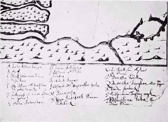
Fig.4. Detail of Fig.5.
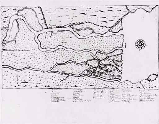
Fig.5. Anonymous MS. Swedish map of the Azov region
[Данную карту в цвете и в хорошем качестве можно посмотреть здесь - LV]
It is possible that this was the draft of the map shown by Major General Hård to the Khan in his above-mentioned audience and discussion of the operations to be undertaken against Azov in 1711.
There is also a Turkish MS. map10 (see fig. 6) which the author — without having seen the original — attributes to the same epoch. The author was however unable to identify this sketch with any part of the Crimea. On the other hand, it seems to suggest some likeness with the Azov region. [Данную карту более глубоко прорабатывал польский исследователь Зигмунт Абрагамович. По его мнению она изображает план атаки по Днепру на Киев и составлена в промежутке 1495 - 1506 гг. - LV]. It represents an attack from the sea against four fortified points situated near one another on the delta of a river.
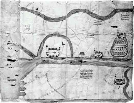
Fig.6. MS. Turcish map of the Azov(?) region
(Topkapu Saray Library, Istanbul)
The inscriptions with which these fortified points are provided are evidently not their names, because they all contain the Turkish word "ka'iyé"11. The inscription at the smallest of these points reads "ka'iyé merkez girmen" (= entrance to centre of ka'iye). The text below it is a dedication, which, freely translated from the Turkish language, reads as follows: "Hereby a humble man lays at the feet of Sultan Khan an adequately made representation: if it so pleases my Sultan, the stones of this river were formed in the day of Nimrod (!, i.e., they are very ancient). May this humble man's (representation?) made in such a way be presented to the royal throne. May your ships (?) .., not be joined (to) ... — Your slave Kulacuti Muraly Ilyas ( = Elias)." (The translation is defective on account of the difficult reading of the text.) [Использованые здесь переводы с турецкого были раскритикованы Абрагамовичем. Так, в частности, он предлагает такой перевод основной надписи на карте: "Дело, изложение которого сей бедняк подает к праху [на] земле [под] стопами моего султана, таково, что если мой султан повелит, то камни, которые [находятся] в этой реке (сотворены же они во времена Нимруда), я, бедняк ваш, раздвину так, чтобы ваши корабли дошли вплоть до королевской столицы и ни у кого [даже] кровь бы из носа не потекла. Ваш слуга проводник мореец Ильяс". Подробнее - см. в статье Абрагамович З. Старая турецкая карта украины с планом взрыва днепровских порогов и атаки турецкого флота на Киев // Восточные источники по истории народов Юго-восточной и Центральной Европы. М., 1969. Т. 2. С. 76-96. - LV].
One more MS. map with Turkish text should be mentioned in this connection (Fig. 7)12. It comprises the littoral region of the north-eastern part of the Black Sea from the estuary of the Don, around the Azov Sea, to the town of Gelandzhik south of Novorossiysk. The outline of the coast is painted in brush and is evidently a memorised record of some earlier map, naturally of irregular proportions and devoid of scale. The land area is impressively punctuated. Apparently the map was made with the purpose of memorising the names of river mouths, harbours and populated centres on the coast. The author presumably produced it during a journey in these parts. An annotation made in the right-hand bottom corner of the map bears an indication of its author. We read: "Carte de Crimee et de Palus moeotides levee et dressee par feu monsieur françois Petis De la Croix secretaire Interprete du Roy et Professeur au College Royal et traduite par ordre de Monseigneur le Comte de Monrepos Ministre et secretaire d'Etat par Alexandre-Louis-Maria Petis De la Croix fils de l'auteur. 1734". The names are given both in Turkish (prior to 1680?) and in French (1734).
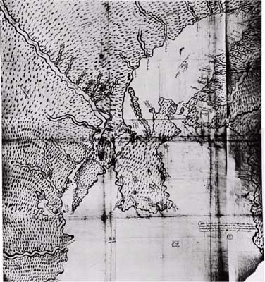
Fig. 7. Carte de Crimee, in Turkish and French, by F. Petis de la Croix, CA. 1680
(Musee de la Marine, Paris)
The father of the abovementioned François bore the same name and likewise was "secretaire interprete du Roi". He was born in 1622 and died in 1695. Francois junior was raised to the nobility with the name of De la Croix; he became professor in Arabic and translated and published a number of works in Arabic, Persian and Turkish; in 1670-80 he made a long journey in the Levant, which he described in "Relations de ses voyages". He was born in 1653 and died in 1713. Finally, Alexandre (1698-1751) inter alia translated from the Turkish language "le Canon du sultan Suleiman II"13.
____________________
The Editor permits himself to complete this article by a few lines14.
In what age the outline of the Crimea and its figure began to take shape in early maps, it is difficult to establish. For this dating we cannot rely on Claudius Ptolemy, who lived and worked in Alexandria, because the question of the origin both of the list of astronomical points and of the maps proper forming his renowned "Geographia" is still disputable. No maps of the Hellenistic age providing us with any point of departure have survived. Nor does the fragment of a Roman soldier's shield, on which a part of the Crimean coast is represented, provide us with any definite data. The so-called Tabula Peutingeriana only vaguely outlines the north coast of the Euxine. The literary monuments (peripli), beginning with Scylax Caryondonsis and Arianus Nicomedensis, indicate in their text many points on the Euxine, but these descriptions do not create any clear conception of the configuration of the coast. And although Arabic travellers are known to have visited the Crimea, they did not represent it in their maps.
Thus we must accept, as the earliest configuration of the Crimea recorded, the triangular shape found in the MS. maps ascribed to Ptolemy, in Codex Saray (Fig. 8).
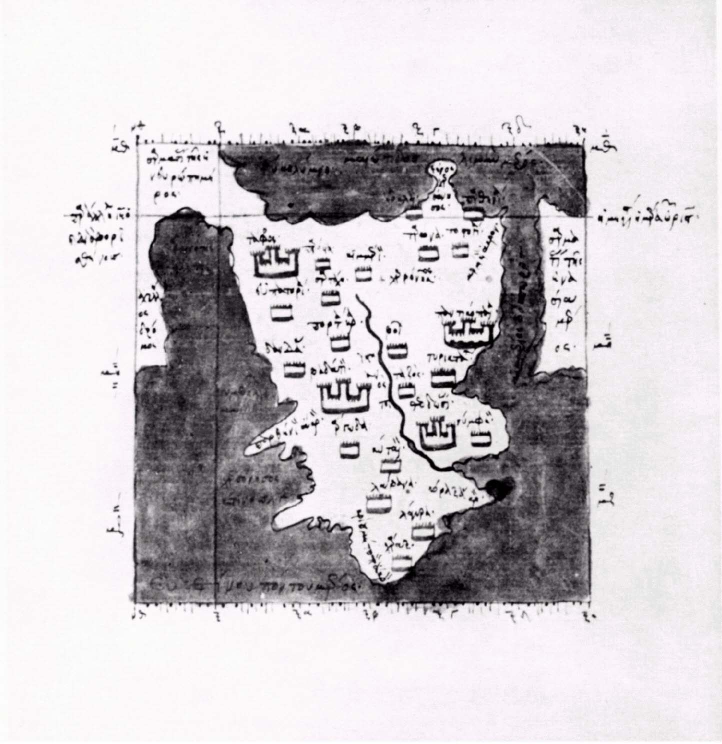
Fig. 8. The Crimea, in the Ptolemaic Codex Saray
(Topkapu Saray Library, Istanbul)
Gradually this triangular shape developed into a rhomboid one which first appeared in the maps of Petrus Vesconte and was later adopted on all the sea-charts and subsequently by other European cartographers (Fig. 9A-D). This type is represented here by a reproduction (Fig. 9E) from a printed map in Bordone's Isolario of 1528. For centuries this shape was maintained, until the French engineer Le Vasseur de Beauplan, constructing a map of Southern Russia for the King of Poland, gave the Crimea a round shape. This new configuration was presumably accepted also on Russian maps. However, we may also presume the converse, because Beauplan's maps do not usually contain the Crimea, except for the Perekop Isthmus, and only one example of his map is provided with a representation of the Crimea, which is however stuck on and goes beyond the frame of the map. This suggests that it might have been borrowed e.g. from the short description of the Crimea by Jacob Sandrart (1687), which is illustrated by a map of this round type (Fig. 9F)15.
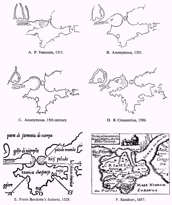
Fig. 9. Early delineations of the Crimea.
Comments
1. V.F.Gnucheva, Geogr. Departament Akademii Nauk XVIII v. (Moscow-Leningrad, 1946), with Appendix by B.V.Alexandrov.
2. Imago Mundi, IX (1952), p.99. The original is now in the Bibliotheque Nationale, Paris.
3. K.Krigsarkivet, Stockholm. Ryssland, Band XXXIII, nr.26.
4. Imago Mundi, IV (1947), p. 65.
5. Swen Lagerbergs Dagbok under vistelsen hos Tartar — Chan Dowlet-Gheray, 1710-1711 (Gothenburg, 1896), p. 1. Comparison was made with the series Tatarica, preserved at the Riksarkivet, Stockholm. Brev från överstelöjtnant Sven Lagerberg till Konung Carl XII1710-1711. Lagerberg was born in 1672, count, Major-General and Privy Councillor. He died in 1746.
6. Ibidem, p. 19.
7. Ibidem, p. 161.
8. Ibidem, p. 194-195.
9. K. Krigsarkivet, Stockholm, Ryssland, Band XXXIV, nr. 32.
10. L. Bagrow found this map during his visit to the Topkapu Saray Library, Istanbul, in 1956. No information on the date and place of preparation of this map could be obtained at the Library, but it was assumed to represent a part of the Crimea.
11. The author is indebted to Prof. H. S. Nyberg of the University of Uppsala for the interpretation of the Osmanli-Turkish text on this map.
12. It was found by L. Bagrow at the Musee de la Marine, Paris.
13. Ludovic Lalanne, Dictionnaire historique de la France (Paris, 1877).
14. Note added by the late L. Bagrow.
15. Des Königreichs Pohlen .... Beschreibung (1687), facing p. 187.
Source: Imago Mundi, 15 (1960), pp. 84-88.
При использовании материалов с данного сайта ссылка на него не обязательна, но желательна : )